[ibimage==34021==Large==none==self==ibimage_align-center]
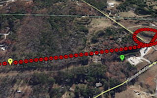
Think of Remote Geo kind of like Google Street view, just for the sky. The Ft. Collins-based startup makes software that allows digital video data to be embedded onto a map. Why, you might ask? Well it turns out there are some pretty interesting applications for just such software.
The software takes video and connects the video’s frames with geographic points on a map. So, if I take a video of my bike ride to the office, you can see where each frame of the video was taken on a map. While nobody cares about my bike ride, this sort of technology is useful to industries that have lots of infrastructure to maintain. Power companies have to ensure thousands of miles of power lines are operating. Should a tree grow too close to a line, or woodpecker eat away at a pole, or a hotspot develop, the power can go out for millions. Pipeline operators have the same sort of problems.
These sorts of companies already use Remote Geo’s software to help watch their infrastructure. While they used to send crews out to track thousands of miles of infrastructure by hand, they can now be much more efficient. Using complex (and expensive) cameras mounted on helicopters they can take a video of a power line or pipeline. Then, when the flight is over, the video can be analyzed from the comfort of an office chair. If they find something, a tree, a hotspot, or whatever, a team can be sent to the exact location to repair it.
But, where this software goes in the future is more interesting. With the increasing availability and sophistication of drones, these camera flights are on the brink of not even needing a pilot. They can simply open the garage door and let out an army of drones — the resulting data can then be analyzed upon the camera drones' return.
In the future Remote Geo is planning to create a cloud-based, consumer model as well. It’ll allow normal, everyday people to upload their video onto a map. Should something like this take off, there’s a potential for a whole new layer of information on maps. Imagine, for example, being able to see what a ski run looks like in HD video before ever setting out. Not only will you know what the run will look like, you'll be able to follow along on a map.
Remote Geo has been bootstrapped since its creation four years ago. Actually, the entire project was started as a sort of part-time, after work endeavor until it took off two years ago. Today there are four fulltime employees and a tentative plan to hire a sales team later this year.
Have a tip for us or know of a company that deserves coverage? Email us via [email protected]


